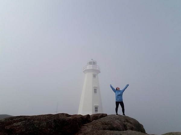
Shelby Blackley stands at Canada's easternmost point – the Cape Spear Lighthouse.Shelby Blackley/The Globe and Mail
“Travelling home or visiting?”
My seat mate was staring at me as I came out of my in-flight nap.
“Visiting. I’m driving from St. John’s to Deer Lake,” I said. “By myself.”
He looked shocked. Perhaps he was right to be. In that moment, looking out the airplane window at the island we were about to land on, I was surprised at myself. This wasn’t my first solo trip – but it definitely felt like a challenge.
Newfoundland is not small. It’s 405,212 square kilometres of greenery, small towns and vacant areas. My goal was to cover as much as possible across the Trans-Canada Highway – which runs between St. John’s and Port-aux-Basques at the western corner – in five days and four nights.
Day 1: Saturday, June 8
It’s my first time in the province, so I spend the afternoon exploring St. John’s and the surrounding area. I buy some souvenirs at Posie Row, down a beer flight at Yellowbelly Brewery (the Wexford Wheat was my favourite) and fuel up on a chai latte with oat milk at Rocket Bakery.
I venture out of the city for an unofficial start to the road trip at Cape Spear. The fog is rolling in and I can barely see a few feet in front of me. I follow the pathway until I am at the easternmost point in Canada, standing on a ledge. I try to see anything out in front of me, but can’t. The rest of the trip will offer better views, I hope.
Driving distance: 70 km
Day 2: Sunday, June 9
I’m up early so I have time to fit in a visit to Signal Hill, a National Historic Site, and a hiking trail that takes me to the edge of the harbour. It’s quiet, but it gives me a chance to sit and look out on the ocean. I spot a few baby icebergs and think about how much joy this place brings me – the peacefulness, the simplicity, the kindness.
I visit Quidi Vidi before I hit the road. It’s a place where, once you arrive, you feel you’ve travelled far, when it’s really just a 10-minute drive from downtown St. John’s.
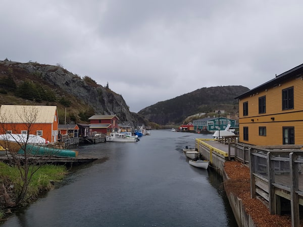
The neighbourhood of Quidi Vidi, home of the Quidi Vidi Brewery.Shelby Blackley
The neighbourhood is best known for the Quidi Vidi Brewery. The second-floor tap room offers a breathtaking view of the lake and the mountains behind the village. I feel right at home when I grab a seat at the bar and try a house beer made using 20,000-year-old iceberg water.
I ask the bartender what there is to do between there and Gander, the next stop on my list. “Watch out for the moose,” he replies. Oh, alright then.
Driving distance: 294 km
Day 3: Monday, June 10
On my way to Burlington, a little town off the Trans-Canada, I detour west to the Twillingate Islands in Notre Dame Bay. I have yet to see a large iceberg and am determined to hunt some out.
I drive through the main area, telling myself not to get my hopes up.
And then I clear the hill.
In a small bay of water called Little Wild Cove, I spot one. It is wide, with a single peak that points at least 50 feet into the sky. I pull over, climb some rocks to get as close as possible and take my first-ever iceberg selfie.
And the excitement continues: I get to stay in a converted lighthouse tonight.
I ask my hosts where to find icebergs nearby, and instead of just giving me directions, they exhibit that famous Newfoundland hospitality and insist on taking me.
We drive for a bit and then hike our way out to a cliff. It’s a beautiful view, but the water is empty. I’m pleased; my hosts are not. "This way!” they shout.
We try a different route, and off a beach close to King Island is an iceberg - bigger than the one in Twillingate – with the sun setting behind the cliffs. My smile is huge.
Driving distance: 320 km
Day 4: Tuesday, June 11

The Tablelands of Gros Morne National Park are where the continents of North America and Africa once collided.Shelby Blackley
Two hours after leaving Burlington, I hit Gros Morne, which almost instantly becomes one of my favourite national parks. The landscape is breathtaking and requires a steady hand when driving. I spend a good chunk of the day in the park, walking various paths and stopping at every possible lookout. It’s a particularly beautiful day, not a cloud in the sky and 18 degrees (warm for the island). I stop for awhile on the Tablelands, an area where the continents of Africa and North America collided. I sit for a good half hour, taking in the stark difference between plains and mountains. Again, I’m alone. And I’m enjoying it so, so much.
I end my day at Trout River, a town on the Gulf of St. Lawrence in the south end of the park. It is here I discover Seaside Restaurant, one of the best seafood joints I’ve ever been to. I order a heaping serving of snow crab (10 huge legs), a Caesar salad (because I’m healthy) and wash it down with an Iceberg beer.

Snow crab and Caesar salad at Seaside Restaurant in Trout River, Nfld.Shelby Blackley
Driving distance: 280 km
Day 5: Wednesday, June 12
I head out to see the rest of the park – or at least as much as I can before I have to catch my flight. Still no moose, surprisingly, but I do see a bear and her baby cub.
I’m early for my flight so I sit in the café at Deer Lake Regional Airport reflecting on the journey I just finished. I’m disappointed in some aspects – I wish I had more time to hit up St. Anthony and the western part of the Trans-Canada Highway, but I’m proud of how much ground I covered. I finish my book – and then start making plans to conquer Labrador.
Total driving: 1,053 km
Live your best. We have a daily Life & Arts newsletter, providing you with our latest stories on health, travel, food and culture. Sign up today.
 Shelby Blackley