The river
From its terminus at Montreal, with tributaries that reach deep into the heart of central Canada, the Ottawa River drains more than 146,000 square kilometres – a larger footprint than many European countries, including Ireland, Hungary and Greece.
Yet the river is also one of Canada's most regulated waterways, with 13 major reservoirs and more than 50 major dams and hydroelectric generating stations along the system.
So how can a river with so many controls still manage to flood its banks, causing loss of life and what will almost certainly turn out to be many millions of dollars in property damage? The answer is that most of the controls and all of the reservoirs are on the upper third of the river basin.
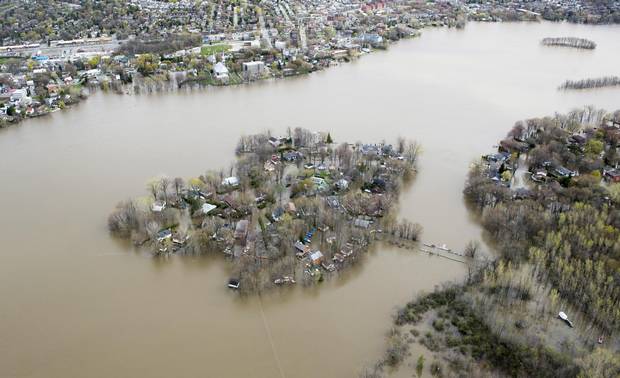
Ile Mercier covered in floodwater is seen on the Riviere des Prairies on the north part of Montreal, on May 8, 2017.
PAUL CHIASSON/THE CANADIAN PRESS
"The southern two thirds of the basin essentially has no substantial storage on it," says Michael Sarich, a senior water-resources engineer with the Ottawa River Regulation Secretariat, which oversees procedures related to water levels on the river.
This means once water gets beyond the reservoirs and is running freely through the most populated regions of the Ottawa Valley, regulators have no capacity to hold water back at times when flows are unusually large or respond to rising levels due to precipitation that falls below the reservoirs.
The rain
Spring is normally a high water season because of snow melt that feeds the Ottawa River at this time of year. On top of that, accumulated rainfall in April was at its highest in at least two decades throughout the Ottawa Valley region – inundating the river basin with more than double the amount of precipitation that falls in average years. Most of this rain fell in areas below the reservoirs, creating a growing and effectively uncontrolled potential for flooding that set the stage for what happened next.
In the first week of May, two more bouts of heavy rain added still more water to the swollen rivers. At the same time, reservoirs upstream were already at capacity and discharging large volumes of water – a necessary measure to avoid dams being overtopped and damaged.

Data from Canada’s RADARSAT-2 satellite was used to construct this view of flooding around Lac des Deux-Montagne in Quebec, where the Ottawa River encounters the island of Montreal. The blue in the image shows the extent of open water on May 7, 2017, while the outlines of flooded lands appear in lighter blue.
Natural Resources Canada, Canadian Space Agency
For example, on May 5, the Timiskaming Reservoir was effectively at its maximum level and discharging close to 1,900 cubic metres per second, far more than the entire Ottawa River at periods of low flow. A few days later, on May 8, outflow at the Carillon Dam at the bottom of the river had reached a record high of nearly 9,000 cubic metres per second. What happened between the top and bottom of the river during those three days is something that system managers say they were helpless to prevent or mitigate.
"It's just an unprecedented event," says Mr. Sarich. "So then it becomes a problem of people in the floodplain, and that's just a more difficult question."
The climate
As unprecedented as the rainfall was, scientists say residents can expect more of the same in the years ahead – and it's unlikely the outcome will be any different from a water management point of view.
"These are the types of events brought by climate change that climatologists have been predicting for 30 years – they're just starting to show themselves now," says Adam Fenech, who heads the University of Prince Edward Island's climate lab.
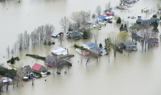
Flooded homes are seen on Monday, May 8, 2017 in Rigaud, Que., west of Montreal.
PAUL CHIASSON/THE CANADIAN PRESS
The thermodynamics behind the trend are well-established: for every degree Celsius that a parcel of air warms, the amount of moisture the air can hold rises by about 7 per cent. Average annual temperatures in parts of the Ottawa River basin have already increased by close to one degree in the past 60 years and the warming trend is only projected to accelerate due to greenhouse-gas emissions.
That means more water is being ferried up to the region when weather patterns carry moisture from the Gulf of Mexico, and the potential for periods of high precipitation is greater now than in the past.
An additional factor may be the jet stream that some scientists say is more likely to take on a meandering pattern rather than a straight west-to-east flow as the Arctic warms. The bends in the jet stream can act as roadblocks that tend to keep weather patterns in place over a given region for longer stretches of time. In other words, when it rains it rains longer, putting more pressure on watersheds.
As to whether this past week's flooding can be attributed to climate change, Blair Feltmate, who heads the Intact Centre on Climate Adaptation at the University of Waterloo, compares the situation to that of a baseball player on steroids.
"You can't say any single home run is due to the steroids," said Dr. Feltmate. But as the player's total home run count starts to climb, it's increasingly obvious that the drugs are having an effect.
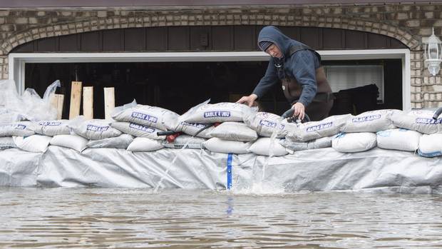
Patrice Pepin walks along a barrier of sandbags holding back the Ottawa River’s waters at the home of his brother Christian Pepin and wife Marie-Pierre Chalifoux on Fournier street in the municipality of Saint-Andre-d’Argenteuil, on May 9, 2017.
Dario Ayala/The Globe and Mail
The risk
If major floods can't be prevented and also show every sign of increasing in frequency in the coming decades, what does that mean for property owners and their insurers?
In a word, it means more risk.
"Flooding is the elephant in the room for Canada," says Dr. Feltmate. "That is the most challenging aspect of climate change – and the most costly to the country."
And increased flooding is not just a problem that will be restricted to major waterways like the Ottawa River. The phenomenon of microbursts – sudden downpours that can overwhelm storm drains and sewer systems when they strike in a geographically localized area – can affect homes and neighbourhoods that are far from any natural shoreline. In areas where drainage systems converge, some homes that never knew flooding are now in a position to be struck by repeated events, to the point where they become uninsurable. The problem, says Dr. Feltmate, is that both governments and homeowners are still very much in the mode of "management by disaster," which means they tend to pay attention to the flooding problem only while a flood is under way.
Meanwhile, there is plenty of work that homeowners can do, starting with making sure that their homes are covered by the different kinds of flooding – overland and sewer backup – that can occur. To the extent possible, homes should be protected with features such as plastic covers over basement window wells and sump pumps with backup generators so that they don't shut down when the power goes out.
Municipalities, meanwhile, need to generate accurate flood maps so that high-risk areas can be identified ahead of time.
And if there's one message that Canadians should be taking away from the Ottawa River flood of 2017 it's this, Dr. Feltmate said:
"These floods we're realizing now are small compared to what's coming."
FLOODS IN QUEBEC: MORE FROM THE GLOBE AND MAIL


